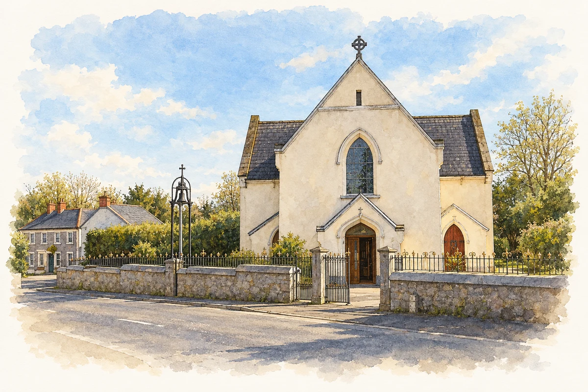
Raharney's bridge and church preserve nineteenth-century village landmarks. Its emigrants maintained strong links with home, while hurling became another enduring focus of community life.
Illustration, St Brigid's Church, Raharney
⊕Recorded locationRaharney53.52456° N · 7.09601° WInteractive map supplied by OpenStreetMap.
These Irish name elements are associated with this record in the Logainm glossary.
An element’s translation is a clue, rather than a complete explanation of the name. Its form and meaning depend on local history and the full Irish name.
Recorded forms
Ráth Fhearna· Irish · main form · validated name
Raharney· English · main form
Place & story
The bridge over the Deel
Raharney's three-arched stone bridge crosses the River Deel at the village. The county tourism account records its renovation in 1848 under a Famine relief scheme. The crossing and nearby riverside park give the settlement a clear centre, with the water running through a place closely connected to neighbouring Killucan. The bridge's history links a familiar route through the village with nineteenth-century public works and the emergency employment of the Famine years.[2]
A chapel built in 1834
A lease dated 4 March 1834 survives in the diocesan archives for the land used to build Saint Brigid's. Parish priest John Curran erected the chapel later that year, and Eugene O'Rourke renovated it in 1860. An exterior inscription commemorates both phases. The T-shaped building retains a timber roof, pointed windows and a separate cast-iron belfry. A stained-glass Crucifixion window acknowledges the Raharney Rovers of New York as its donors, making the emigrant connection visible inside the church.[3][4]
People & connections
Christopher Murray's transatlantic links
Christopher Murray was born in Raharney in 1871 and emigrated to the United States in 1894. Writing as the Raharney Rover, he began contributing to the Westmeath Examiner in 1896. When the storm-damaged church needed help, the New York Rovers organised fundraising events; its new glass was in place when worship resumed in October 1905. Murray also donated a holy-water font in memory of his parents. He later served as a New York commissioner of weights and measures, while continuing his newspaper correspondence with home.[5]
Keeping hurling rooted in the village
Five Raharney club members recorded their experiences for the GAA Oral History Project. Their account covers playing careers, local rivalries, Féile na nGael and contacts with overseas clubs. It also describes the work behind the matches: fundraising, improving facilities and encouraging players to remain committed to hurling in a county where football offered a higher profile. Their recollections document the practical effort required to keep a village sporting institution active across generations.[6]
Both counts use the 2016 settlement boundary, allowing like-for-like comparison. CSO supplies the 2022 count on this older boundary for comparison only. The official 2022 Built Up Area has different boundaries.
View population figures
Raharney — Census 2016 settlement footprint — census population
Raharney, Westmeath — Census town, CSO 2006 report
2002–2006: census town
231people · 2006
These are the historical areas published in the 2006 census report. Boundaries may differ between censuses and from modern settlements. Legal towns, environs and suburbs are shown separately; none has been combined into a modern settlement total.
View population figures
Raharney, Westmeath — Census town, CSO 2006 report — census population
Raharney, Westmeath — Census town, CSO 1996 report
1991–1996: census town
232people · 1996
These are the historical areas published in the 1996 census report. Boundaries may differ between censuses and from modern settlements. Legal towns, environs and suburbs are shown separately; none has been combined into a modern settlement total.
View population figures
Raharney, Westmeath — Census town, CSO 1996 report — census population
Raharney, Westmeath — Census town, CSO 1986 report
1981–1986: census town
260people · 1986
Figures cover the historical town area printed in the 1986 report. Boundaries may have changed between censuses. Legal town, environs and suburb totals remain separate and differ from modern settlement boundaries.
View population figures
Raharney, Westmeath — Census town, CSO 1986 report — census population
These figures use different area definitions. Read the boundary note before comparing them.
Raharney, Westmeath
Published census settlement populations
221people · 2016
Settlement boundaries changed during this period. Differences may reflect boundary changes as well as population change. Where a 2011 legal-town-and-environs count is shown, it has not been recalculated onto the 2016 settlement boundary.
St Brigid's Church, Raharney illustration: based on a IMG Raharney5701c.jpg by Sarah777 at English Wikipedia. AI-assisted watercolour and ink adaptation; cream paper margins added, incidental clutter omitted and fine details simplified. Licence: Public domain, released by copyright holder (PD-user).
 placenames