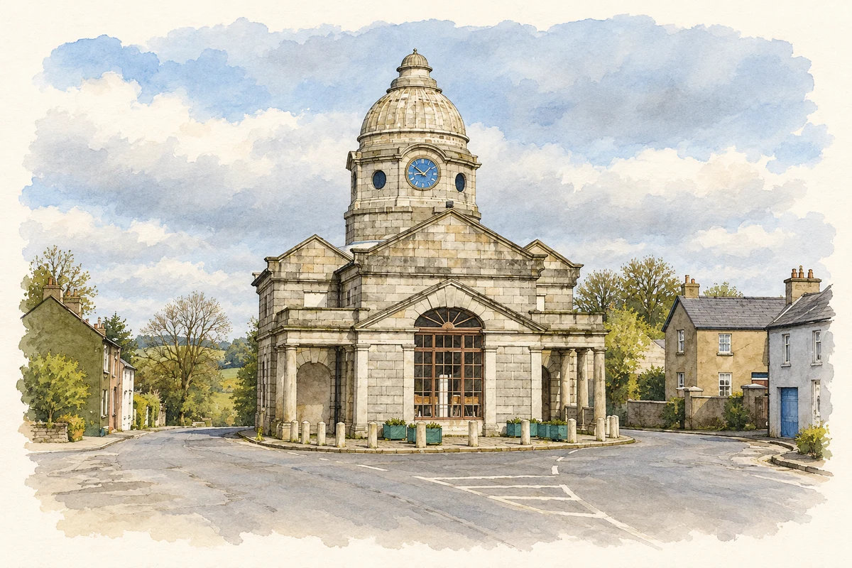
Dunlavin’s distinctive market house and triangular green preserve the setting of ordinary trade and the violence of 1798, while other local traditions reach beyond those events.
Illustration, Dunlavin Courthouse and Market House
⊕Recorded locationDunlavin53.05693° N · 6.69858° WInteractive map supplied by OpenStreetMap.
These Irish name elements are associated with this record in the Logainm glossary.
An element’s translation is a clue, rather than a complete explanation of the name. Its form and meaning depend on local history and the full Irish name.
Recorded forms
Dún Luáin· Irish · main form · validated name
Dunlavin· English · main form
Place & story
Granite columns at the centre of the village
Dunlavin's market house was built in the late 1730s and early 1740s, with its design attributed to Richard Castle. Constructed in granite, it has a cruciform plan, Doric colonnades and an octagonal domed lantern carrying clock faces. The National Inventory of Architectural Heritage identifies it as a building of national importance. Its open corners originally related to the practical business of a market, while the formal architecture expressed the ambition of the town's patrons. Later use as a courthouse added another public function to the same prominent building.[2]
The prisoners on the green
On 24 May 1798, prisoners suspected of United Irish activity were taken from the market house and shot on Dunlavin's green. The local heritage trail records thirty-six men in the group, one of whom survived, and additional hangings at the market house. The victims had been detained before taking part in the outbreak of hostilities. A memorial erected in 1948 marked the massacre's 150th anniversary. The green had also served as a place for fairs: remembering both uses makes clear how violence entered a familiar space of trade and community gathering.[3]
People & connections
Jonathan Swift’s church income
Jonathan Swift held the prebend of Dunlavin from 1700 until 1713, when he became dean of Saint Patrick's Cathedral. The Wicklow Uplands heritage account explains that the appointment provided income from parish tithes and a cathedral stall. It does not establish that he lived in the village. This is an ecclesiastical and financial connection with the writer, useful precisely because it can be stated more accurately than a vague claim that Dunlavin was his home.[4]
Folklore & tradition
Saint Nicholas’s well
The local heritage trail records a pattern, or devotional gathering, at Saint Nicholas's holy well. Belief in cures attributed to its water formed part of that tradition. The account describes the suppression of the gathering in the nineteenth century and its revival in the late twentieth. These are records of religious practice and local belief, not evidence that the water treats illness. The well adds another remembered place to a village whose history is often dominated by the market house and 1798.[4]
Both counts use the 2016 settlement boundary, allowing like-for-like comparison. CSO supplies the 2022 count on this older boundary for comparison only. The official 2022 Built Up Area has different boundaries.
View population figures
Dunlavin — Census 2016 settlement footprint — census population
These are the historical areas published in the 2006 census report. Boundaries may differ between censuses and from modern settlements. Legal towns, environs and suburbs are shown separately; none has been combined into a modern settlement total.
View population figures
Dunlavin, Wicklow — Census town, CSO 2006 report — census population
These are the historical areas published in the 1996 census report. Boundaries may differ between censuses and from modern settlements. Legal towns, environs and suburbs are shown separately; none has been combined into a modern settlement total.
View population figures
Dunlavin, Wicklow — Census town, CSO 1996 report — census population
Figures cover the historical town area printed in the 1986 report. Boundaries may have changed between censuses. Legal town, environs and suburb totals remain separate and differ from modern settlement boundaries.
View population figures
Dunlavin, Wicklow — Census town, CSO 1986 report — census population
These figures use different area definitions. Read the boundary note before comparing them.
Dunlavin, Wicklow
Published census settlement populations
838people · 2016
Settlement boundaries changed during this period. Differences may reflect boundary changes as well as population change. Where a 2011 legal-town-and-environs count is shown, it has not been recalculated onto the 2016 settlement boundary.
Dunlavin Courthouse and Market House illustration: based on a Dunlavin Courthouse by Jonathan Billinger. AI-assisted watercolour and ink adaptation; cream paper margins added, incidental clutter omitted and fine details simplified. Licence: CC BY-SA 2.0.
 placenames