Castletownbere's sheltered waterfront grew with copper mining and naval activity, then developed into a major fishing harbour with a literary connection to the Gaelic Revival.
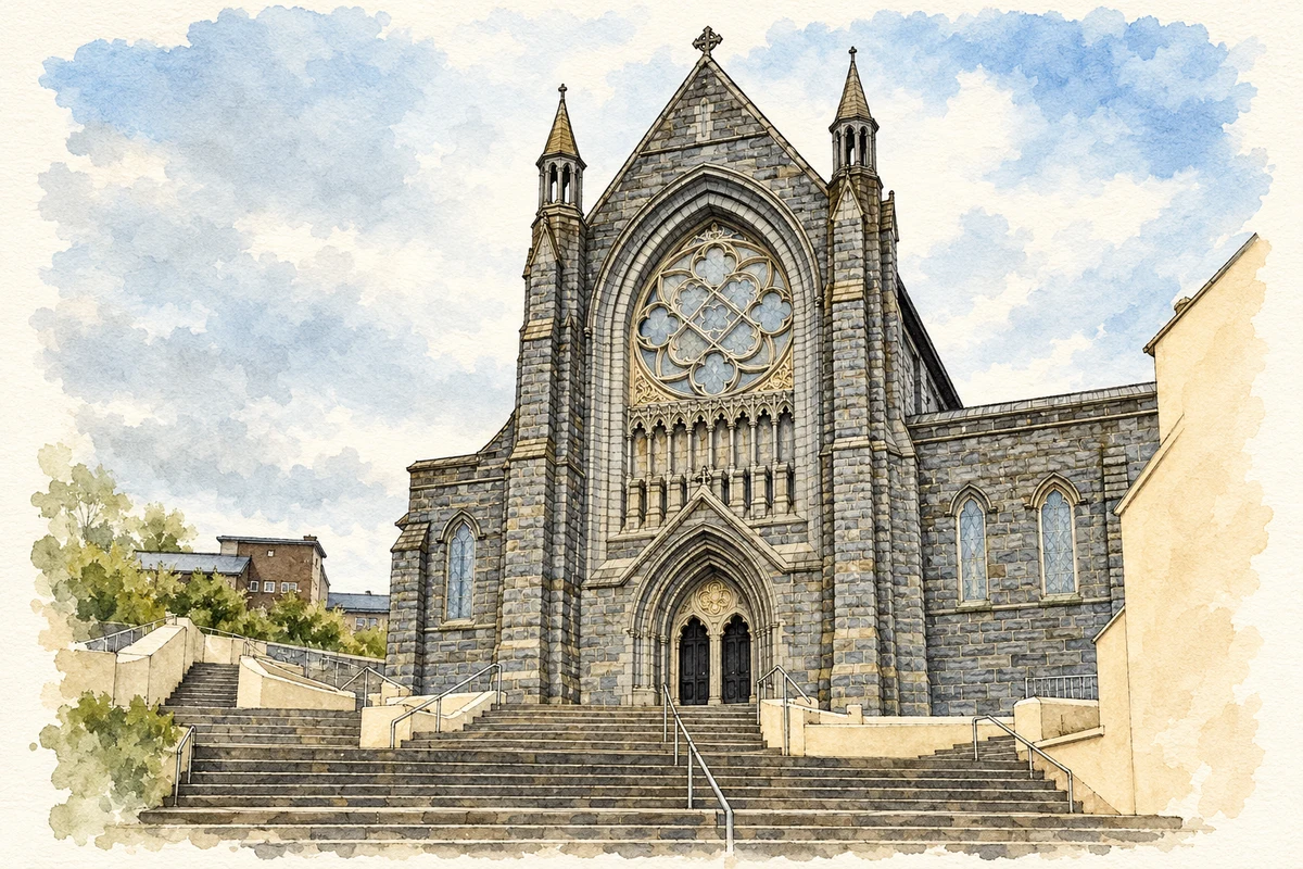
Illustration, Sacred Heart Church entrance, Castletownbere, County Cork
⊕Recorded locationCastletownbere51.65288° N · 9.90004° WInteractive map supplied by OpenStreetMap.
These Irish name elements are associated with this record in the Logainm glossary.
An element’s translation is a clue, rather than a complete explanation of the name. Its form and meaning depend on local history and the full Irish name.
Recorded forms
Baile Chaisleáin Bhéarra· Irish · main form · validated name
Castletownbere· English · main form
Castletown Bearhaven· English · main form
Castletown Bere· English · main form · local name
Place & story
The waterfront town of 1837
Samuel Lewis described Castletownbere in 1837 as a rapidly growing town of more than three hundred houses, stretched along the inner bay opposite Bere Island. He linked its development with the discovery of copper at Allihies in 1812, recalling that it had previously consisted of only a few fishing cabins. The contrast gives a vivid measure of the changes brought by mining in the wider Beara peninsula. Shops and newly built houses occupied the waterfront of a harbour whose sheltered position supported the expanding settlement.[2]
People & connections
Standish James O'Grady's birthplace
Standish James O'Grady was born at the Glebe in Castletownbere in 1846, the son of a Protestant rector. His English-language versions of Irish heroic stories helped stimulate the literary revival, influencing writers including W. B. Yeats, Lady Gregory and George Russell. The county council's town trail identifies this local birthplace within a career later pursued through writing, journalism and historical interpretation. O'Grady's importance lies in the new readership he brought to early Irish narrative and in the creative work his books encouraged among a later generation.[3]
Granite brought by sea
The Sacred Heart Catholic church was built in 1911 on the site of an earlier church. Granite travelled from the Mourne Mountains by sea for its construction. Donations came from Irish people in the United States and British naval personnel stationed in Berehaven, reflecting two different overseas connections in the town's life. Stone carving, woodwork and stained glass enrich the interior. The building's large Gothic form remains a prominent reminder of the resources and craftsmanship assembled for this early twentieth-century parish project.[3]
Building a fishing harbour
An RTÉ news report from April 1962 records plans for a major new quay at Dinish Island, a bridge to the mainland and a fishmeal plant. The footage belongs to a wider programme of investment in selected Irish fishing ports. It captures Castletownbere at another point of economic change, as harbour engineering and processing facilities expanded the possibilities of the fishing industry. Dinish Island became closely linked with the town's working waterfront, adding a new industrial chapter to a harbour already shaped by mining and naval use.[4]
Both counts use the 2016 settlement boundary, allowing like-for-like comparison. CSO supplies the 2022 count on this older boundary for comparison only. The official 2022 Built Up Area has different boundaries.
View population figures
Castletownbere — Census 2016 settlement footprint — census population
Castletownbere, Cork — Census town, CSO 2006 report
2002–2006: census town
868people · 2006
These are the historical areas published in the 2006 census report. Boundaries may differ between censuses and from modern settlements. Legal towns, environs and suburbs are shown separately; none has been combined into a modern settlement total.
View population figures
Castletownbere, Cork — Census town, CSO 2006 report — census population
Castletownbere, Cork — Census town, CSO 1996 report
1991–1996: census town
926people · 1996
These are the historical areas published in the 1996 census report. Boundaries may differ between censuses and from modern settlements. Legal towns, environs and suburbs are shown separately; none has been combined into a modern settlement total.
View population figures
Castletownbere, Cork — Census town, CSO 1996 report — census population
Castletownbere, Cork — Census town, CSO 1986 report
1981–1986: census town
905people · 1986
Figures cover the historical town area printed in the 1986 report. Boundaries may have changed between censuses. Legal town, environs and suburb totals remain separate and differ from modern settlement boundaries.
View population figures
Castletownbere, Cork — Census town, CSO 1986 report — census population
These figures use different area definitions. Read the boundary note before comparing them.
Castletownbere, Cork
Published census settlement populations
860people · 2016
Settlement boundaries changed during this period. Differences may reflect boundary changes as well as population change. Where a 2011 legal-town-and-environs count is shown, it has not been recalculated onto the 2016 settlement boundary.
Sacred Heart Church entrance, Castletownbere, County Cork illustration: based on a Sacred Heart Church, Castletownbere by PAUL FARMER. AI-assisted watercolour and ink adaptation; cream paper margins added, incidental clutter omitted and fine details simplified. Licence: CC BY-SA 2.0.
 placenames