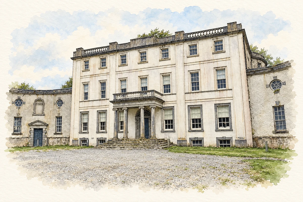
Strokestown's house and papers preserve both estate life and unusually detailed evidence of the famine, emigration and appeals for help that shaped the surrounding countryside.
Illustration, front facade of Strokestown Park House
⊕Recorded locationStrokestown53.77624° N · 8.10602° WInteractive map supplied by OpenStreetMap.
These Irish name elements are associated with this record in the Logainm glossary.
An element’s translation is a clue, rather than a complete explanation of the name. Its form and meaning depend on local history and the full Irish name.
Recorded forms
Béal na mBuillí· Irish · main form · validated name
Strokestown· English · main form
Place & story
A house built around an earlier home
Strokestown Park's Palladian appearance conceals an earlier house completed in 1696. Eighteenth-century rebuilding added flanking pavilions and a more formal composition, possibly to designs by Richard Castle. Its fabric subsequently required substantial conservation: the Irish Georgian Society records problems with dry rot in the library wing and damage to historic decoration and wallpaper. The house's architectural history is therefore preserved through both its successive enlargements and the later work needed to protect the interiors and collections remaining within it.[2]
The emigrants of 1847
The estate archive names 1,490 men, women and children who left through Major Denis Mahon's assisted-emigration scheme in 1847. Lists compiled by his agent and bailiffs record families, debts and arrangements for giving up holdings. An April letter from Mahon reveals his concern to remove poorer occupants who might become a charge on poor relief. These documents connect the scheme's administrative language with individual households. They preserve the names behind a migration that carried people from the Strokestown estate through the famine and across the Atlantic.[3]
Petitions and a museum's beginnings
Letters and petitions in the archive record tenants, landless labourers and cottiers appealing for help as hunger and eviction intensified. The Cloonahee Petition of 1846 became especially important: James Callery discovered it after purchasing the property, and it helped inspire the National Famine Museum. Other papers document Major Mahon's assassination in November 1847 and its aftermath. Together, the records preserve several perspectives on the estate, including the people seeking food or security and those administering their rent, relief and departure.[3]
The work of the gallery kitchen
Strokestown's eighteenth-century gallery kitchen preserves ranges, ovens, mechanised roasting spits and smokers, alongside equipment from later generations. The Irish Heritage Trust's 2024 exhibition drew on household records and National Library material to examine the work of its largely female kitchen staff. It also considered the rules and hierarchy under which they worked and the decline in servant numbers after the First World War. The surviving kitchen adds the labour of cooking and serving to the history represented by the house's reception rooms and portraits.[4]
Both counts use the 2016 settlement boundary, allowing like-for-like comparison. CSO supplies the 2022 count on this older boundary for comparison only. The official 2022 Built Up Area has different boundaries.
View population figures
Strokestown — Census 2016 settlement footprint — census population
Strokestown, Roscommon — Census town, CSO 2006 report
2002–2006: census town
773people · 2006
These are the historical areas published in the 2006 census report. Boundaries may differ between censuses and from modern settlements. Legal towns, environs and suburbs are shown separately; none has been combined into a modern settlement total.
View population figures
Strokestown, Roscommon — Census town, CSO 2006 report — census population
Strokestown, Roscommon — Census town, CSO 1996 report
1991–1996: census town
572people · 1996
These are the historical areas published in the 1996 census report. Boundaries may differ between censuses and from modern settlements. Legal towns, environs and suburbs are shown separately; none has been combined into a modern settlement total.
View population figures
Strokestown, Roscommon — Census town, CSO 1996 report — census population
Strokestown, Roscommon — Census town, CSO 1986 report
1981–1986: census town
620people · 1986
Figures cover the historical town area printed in the 1986 report. Boundaries may have changed between censuses. Legal town, environs and suburb totals remain separate and differ from modern settlement boundaries.
View population figures
Strokestown, Roscommon — Census town, CSO 1986 report — census population
These figures use different area definitions. Read the boundary note before comparing them.
Strokestown, Roscommon
Published census settlement populations
825people · 2016
Settlement boundaries changed during this period. Differences may reflect boundary changes as well as population change. Where a 2011 legal-town-and-environs count is shown, it has not been recalculated onto the 2016 settlement boundary.
Central front facade of Strokestown Park House illustration: based on a Strokestown Park House by Marathon. AI-assisted watercolour and ink adaptation; cream paper margins added, incidental clutter omitted and fine details simplified. Licence: CC BY-SA 2.0.
 placenames