These Irish name elements are associated with this record in the Logainm glossary.
An element’s translation is a clue, rather than a complete explanation of the name. Its form and meaning depend on local history and the full Irish name.
Recorded forms
Lios Tuathail· Irish · main form · validated name
Listowel· English · main form
Place & story
The castle above the ford
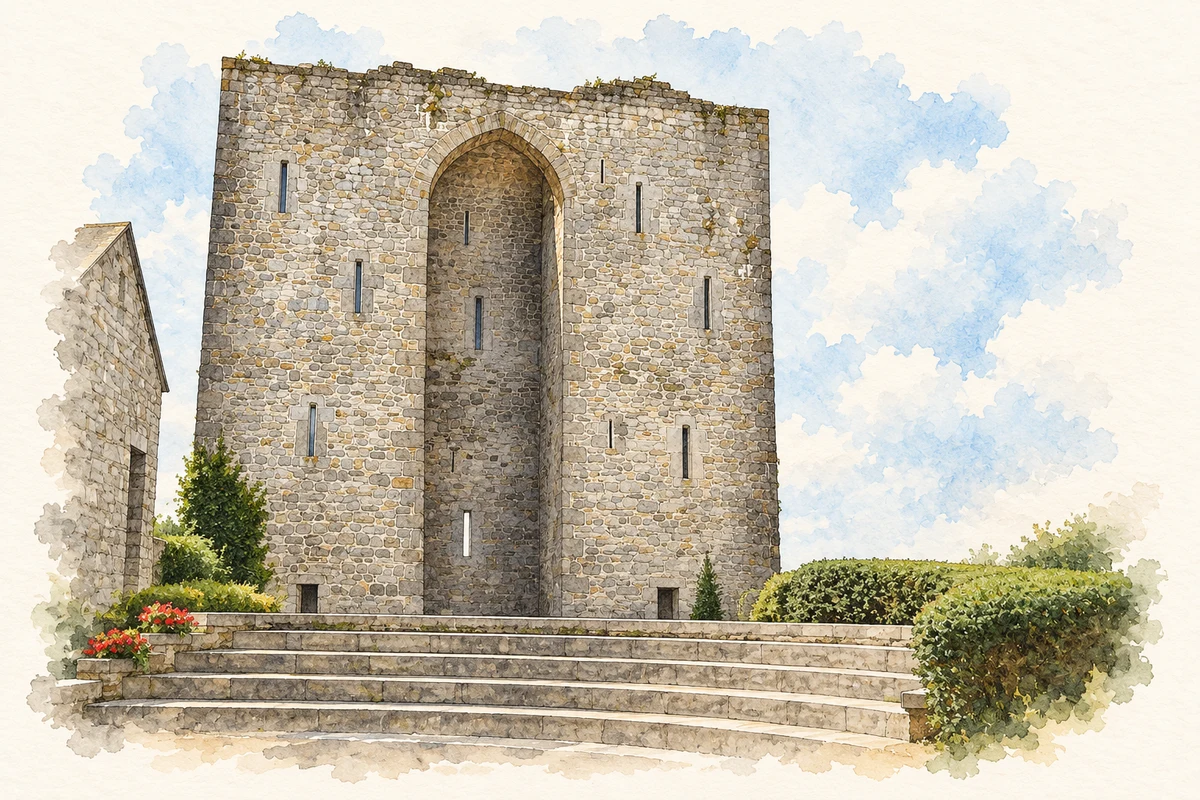
Listowel Castle stands above a strategic crossing of the Feale. Two square towers and a connecting curtain wall survive from the larger building, with an unusual high arch linking the towers on one side. The Office of Public Works records a siege in 1600, when the Fitzmaurice garrison resisted Charles Wilmot’s forces for twenty-eight days before surrendering. The defenders remaining inside were subsequently executed.[2]
A square, mills and fairs
Lewis’s 1837 account describes a spacious square, a principal street and smaller branching streets, with a five-arched bridge across the Feale. Livestock fairs drew cattle, sheep and pigs into the town. Flour mills behind the castle and elsewhere along the river connected this market centre with the surrounding farming economy. Several new houses and two hotels reflected continuing nineteenth-century growth.[3]
People & connections
John B. Keane’s William Street base
John B. Keane was born on Church Street in Listowel in 1928. He attended the local national school and Saint Michael’s College before working in several occupations and spending time in Northampton. In 1955 he married Mary O’Connor; they bought the Greyhound Bar at 37 William Street, which remained his home and workplace.[4]
The papers preserved at Trinity College document his plays, correspondence and other writing. The pub supplied a practical base for the playwright’s career within the town whose speech and social life informed his work. His association with Listowel encompassed schooling, paid work, family life and the everyday encounters of a public house.[4]
Both counts use the 2016 settlement boundary, allowing like-for-like comparison. CSO supplies the 2022 count on this older boundary for comparison only. The official 2022 Built Up Area has different boundaries.
View population figures
Listowel — Census 2016 settlement footprint — census population
These are the historical areas published in the 2006 census report. Boundaries may differ between censuses and from modern settlements. Legal towns, environs and suburbs are shown separately; none has been combined into a modern settlement total.
View population figures
Listowel Legal Town, Kerry — Legal town, CSO 2006 report — census population
Listowel Environs, Kerry — Town environs only, CSO 2006 report
2002–2006: town environs only
437people · 2006
These are the historical areas published in the 2006 census report. Boundaries may differ between censuses and from modern settlements. Legal towns, environs and suburbs are shown separately; none has been combined into a modern settlement total.
View population figures
Listowel Environs, Kerry — Town environs only, CSO 2006 report — census population
These are the historical areas published in the 1996 census report. Boundaries may differ between censuses and from modern settlements. Legal towns, environs and suburbs are shown separately; none has been combined into a modern settlement total.
View population figures
Listowel Legal Town, Kerry — Legal town, CSO 1996 report — census population
Listowel Environs, Kerry — Town environs only, CSO 1996 report
1991–1996: town environs only
263people · 1996
These are the historical areas published in the 1996 census report. Boundaries may differ between censuses and from modern settlements. Legal towns, environs and suburbs are shown separately; none has been combined into a modern settlement total.
View population figures
Listowel Environs, Kerry — Town environs only, CSO 1996 report — census population
Figures cover the historical town area printed in the 1986 report. Boundaries may have changed between censuses. Legal town, environs and suburb totals remain separate and differ from modern settlement boundaries.
View population figures
Listowel, Kerry — Legal town, CSO 1986 report — census population
Listowel, Kerry — Town environs only, CSO 1986 report
1981–1986: town environs only
199people · 1986
Figures cover the historical town area printed in the 1986 report. Boundaries may have changed between censuses. Legal town, environs and suburb totals remain separate and differ from modern settlement boundaries.
View population figures
Listowel, Kerry — Town environs only, CSO 1986 report — census population
These figures use different area definitions. Read the boundary note before comparing them.
Listowel, Kerry — 2011 legal town and environs; 2016 census settlement
Published census settlement populations
4,820people · 2016
Settlement boundaries changed during this period. Differences may reflect boundary changes as well as population change. Where a 2011 legal-town-and-environs count is shown, it has not been recalculated onto the 2016 settlement boundary.
View population figures
Listowel, Kerry — 2011 legal town and environs; 2016 census settlement — census population
Conserved surviving towers and linking arch, Listowel Castle, County Kerry illustration: based on a Listowel Castle by N Chadwick. AI-assisted watercolour and ink adaptation; cream paper margins added, incidental clutter omitted and fine details simplified. Licence: CC BY-SA 2.0.
 placenames