These Irish name elements are associated with this record in the Logainm glossary.
An element’s translation is a clue, rather than a complete explanation of the name. Its form and meaning depend on local history and the full Irish name.
Recorded forms
Trá Lí· Irish · main form · validated name
Tralee· English · main form
Place & story
Water beneath the streets
Samuel Lewis’s 1837 account describes part of the river running under a covering through Tralee. Mountain runoff could swell it, while high tides created another threat from the bay. The same account records a Dominican foundation in 1213 and the town’s later importance as an administrative centre. A small urban watercourse, a religious house and the business of county government all helped shape the settlement.[2]
Blennerville’s working landmark
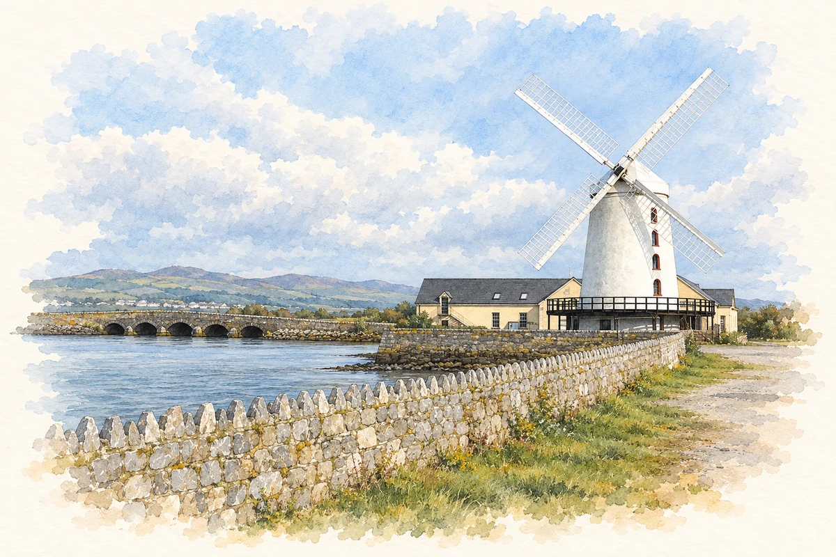
The windmill at nearby Blennerville was built around 1800 for Sir Rowland Blennerhassett, according to its visitor centre. Its successive uses included milling and storage before the building deteriorated into a roofless shell. Restoration during the 1980s returned it to working order. Blennerville was also an emigration port, and the centre connects its maritime history with the original Jeanie Johnston. The restored mill gives that wider history a striking landmark on Tralee Bay.[3]
Folklore & tradition
The Rose remembered in the town park
The Rose of Tralee tradition associates the ballad with Mary O’Connor and William Pembroke Mulchinock. The festival’s own programme presents their romantic story and identifies the statue of the pair in the Rose Garden at Tralee Town Park. A surrounding memorial wall records past Roses. These monuments show how a remembered romance became part of the town’s public identity. Details of the ballad’s authorship have been disputed; the tradition is presented here as the story commemorated locally.[4][5]
People & connections
Roger Casement’s Kerry connection
Kerry County Museum in the Ashe Memorial Hall has explored Roger Casement’s landing at Banna Strand on Good Friday 1916. Its exhibition connects his humanitarian work and later revolutionary activity with the failed arms mission before the Easter Rising. The landing took place on the coast outside Tralee; the town’s museum preserves and interprets its consequences, including the impact on local people and the evidence used at his trial.[6]
Both counts use the 2016 settlement boundary, allowing like-for-like comparison. CSO supplies the 2022 count on this older boundary for comparison only. The official 2022 Built Up Area has different boundaries.
View population figures
Tralee — Census 2016 settlement footprint — census population
These are the historical areas published in the 2006 census report. Boundaries may differ between censuses and from modern settlements. Legal towns, environs and suburbs are shown separately; none has been combined into a modern settlement total.
View population figures
Tralee Legal Town, Kerry — Legal town, CSO 2006 report — census population
Tralee Environs, Kerry — Town environs only, CSO 2006 report
2002–2006: town environs only
2,456people · 2006
These are the historical areas published in the 2006 census report. Boundaries may differ between censuses and from modern settlements. Legal towns, environs and suburbs are shown separately; none has been combined into a modern settlement total.
View population figures
Tralee Environs, Kerry — Town environs only, CSO 2006 report — census population
These are the historical areas published in the 1996 census report. Boundaries may differ between censuses and from modern settlements. Legal towns, environs and suburbs are shown separately; none has been combined into a modern settlement total.
View population figures
Tralee Legal Town, Kerry — Legal town, CSO 1996 report — census population
Tralee Environs, Kerry — Town environs only, CSO 1996 report
1991–1996: town environs only
894people · 1996
These are the historical areas published in the 1996 census report. Boundaries may differ between censuses and from modern settlements. Legal towns, environs and suburbs are shown separately; none has been combined into a modern settlement total.
View population figures
Tralee Environs, Kerry — Town environs only, CSO 1996 report — census population
Figures cover the historical town area printed in the 1986 report. Boundaries may have changed between censuses. Legal town, environs and suburb totals remain separate and differ from modern settlement boundaries.
View population figures
Tralee, Kerry — Legal town, CSO 1986 report — census population
Tralee, Kerry — Town environs only, CSO 1986 report
1981–1986: town environs only
511people · 1986
Figures cover the historical town area printed in the 1986 report. Boundaries may have changed between censuses. Legal town, environs and suburb totals remain separate and differ from modern settlement boundaries.
View population figures
Tralee, Kerry — Town environs only, CSO 1986 report — census population
These figures use different area definitions. Read the boundary note before comparing them.
Tralee, Kerry — 2011 legal town and environs; 2016 census settlement
Published census settlement populations
23,691people · 2016
Settlement boundaries changed during this period. Differences may reflect boundary changes as well as population change. Where a 2011 legal-town-and-environs count is shown, it has not been recalculated onto the 2016 settlement boundary.
View population figures
Tralee, Kerry — 2011 legal town and environs; 2016 census settlement — census population
Blennerville Windmill near Tralee illustration: based on a reference photograph by Kglavin. AI-assisted watercolour and ink adaptation; warm cream paper margins; incidental modern clutter removed and fine details simplified. Licence: CC BY-SA 3.0.
 placenames